
The mountains of northern Vietnam are where the country’s landscape turns dramatic. Limestone karst rises above deep valleys, rice terraces climb whole hillsides, and weekly markets fill with ethnic minority communities in traditional dress. Drives here are slow and winding, and the reward is a side of Vietnam that feels very far from the cities and beaches
What makes northern Vietnam’s mountains worth visiting?

Most trips to Vietnam revolve around cities, beaches and rivers. The northern mountains offer something slower and more immersive, and these are the reasons travelers keep coming back.
- Landscapes that change with every turn. Limestone peaks, deep river gorges and high plateaus give way to pine forests and terraced valleys within a single day’s drive. Fansipan, at 3,143m, is the highest peak in Indochina.
- Rice terraces that look different every season. The same hillside can be flooded and mirror-like in early summer, deep green in July and gold at harvest, so the timing of your visit really shapes what you see.
- Living cultures rather than staged ones. More than 50 ethnic groups live in Vietnam’s northern mountains, including the H’mong, Dao, Tay and Thai. You’ll see it in weekly markets, in the clothing people wear to them, and in the stilt-house villages where families still farm the slopes.
- Roads that are part of the destination. Passes such as Ma Pi Leng in Ha Giang and Tram Ton near Sapa are highlights in their own right, with viewpoints worth stopping at.
- Ways to explore at your own pace. You can trek between villages, cycle quiet valley roads in Mai Chau, ride the Ha Giang Loop, or see the same scenery from a private car with frequent photo stops.
- Homestays and home cooking. Sleeping in a stilt house and sharing a meal with your hosts is often what visitors remember most, more than any single viewpoint.
The trade-off is time. Distances look short on a map, but mountain roads are slow, so the best trips leave room to stop and stay longer than planned.
Where are the northern mountains of Vietnam?
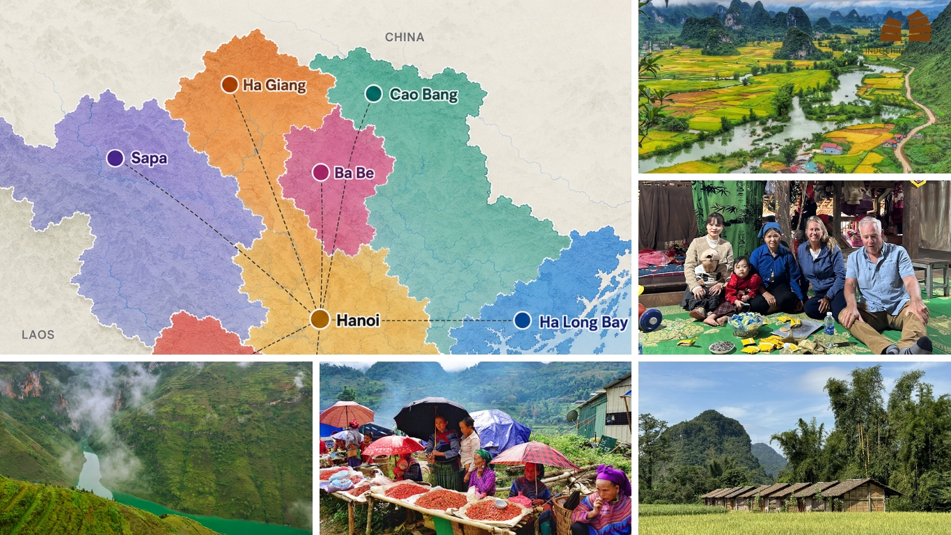
Vietnam’s northern mountains stretch across the highlands north and northwest of Hanoi, up to the Chinese border. The area divides into two regions that feel quite different.
Northwest Vietnam
The Northwest is home to the Hoang Lien Son range and to the country’s best-known terraced landscapes.
- Sapa is the most accessible and best-known mountain base, with hotels, guides and treks to suit most travelers.
- Mu Cang Chai is Vietnam’s iconic rice terrace district, and worth planning your trip around in harvest season.
- Hoang Su Phi is a remote, quieter terraced area. It is technically in the Northeast, but it’s often paired with Northwest routes for travelers who want fewer crowds.
- Mai Chau and Ta Xua are easier or more specialist stops. Mai Chau suits a gentle start or a short break from Hanoi, while Ta Xua suits cloud-hunting and trekking.
Northeast Vietnam
The Northeast has a rawer, more rugged feel, shaped by karst scenery and long road journeys. This is the far north of the country, right on the Chinese border.
- Ha Giang, Dong Van and the Dong Van Karst Plateau form the region’s dramatic heart, home to the famous Ha Giang Loop.
- Cao Bang and Ban Gioc Waterfall bring waterfalls, caves and quiet villages, with far fewer visitors.
You don’t need to visit everything. Your route should depend on what you want most, whether that’s scenery, trekking, culture, road travel or simply a comfortable pace, and on how much time you have.
Best places to visit in northern Vietnam’s mountains
The Hoang Lien Son mountain range dominates northern Vietnam, creating a natural barrier along the Chinese border and housing some of the country’s most spectacular destinations. Let’s hop on a journey with Indochina Voyages through North Vietnam mountainous areas below for the details:
Sapa: the easiest introduction to Vietnam’s mountains
Quick facts:
- From Hanoi: 5–6 hours by road via the Noi Bai–Lao Cai Expressway, or overnight train to Lao Cai plus transfer (8–9 hours in total)
- Best for: first-timers, families, photographers
- Suggested time: 2–3 days
Sapa is the mountain destination most visitors picture first. It’s a former French hill station at around 1,500m, with cool air, valley views, and a good choice of hotels and resorts.

What to do:
- Trek the Muong Hoa Valley. The walk through Lao Chai and Ta Van villages, home to the H’mong and Dzay, takes 3–4 hours and passes terraces, pine forest and family homes. It’s the classic Sapa experience for a reason.
- Take the cable car up Fansipan. The ride removes the multi-day trek, and on a clear day you look out from the highest point in Indochina. Mist is common, so go early and don’t count on the view.
- Visit Cat Cat Village. It’s the easiest introduction to local life, with weaving and handicrafts and a short walk from town, though it is busier than villages further out.
- Explore beyond town. Markets, waterfalls and viewpoints close to the center fill a spare afternoon, and a local guide can help you find quieter routes. On Saturday evenings, the “Love Market” in Sapa’s main square is worth a look, and on Sunday mornings the large Bac Ha market is a day trip away.
An honest note: Sapa is much more developed and tourist-oriented than it was even a decade ago, and the town center can feel busy. It’s still a good choice, especially for families and travelers who want comfort, easy logistics and reliable scenery. To get away from the crowds, base yourself in a valley lodge, hike further out, or add a quieter destination such as Mu Cang Chai or Hoang Su Phi
>> Get to know more about Sapa if finding off-beat experiences there: Sapa Off the beaten track: Insider’s Travel Guide and Things to do
Ha Giang: dramatic mountain roads and the famous loop
Quick facts:
- From Hanoi: 5.5–7 hours by road (expected to shorten as the Tuyen Quang–Ha Giang expressway opens in stages)
- Best for: road-trip lovers, photographers, adventure travelers
- Suggested time: 3–4 days for the loop
Ha Giang is Vietnam’s most dramatic mountain landscape. The Dong Van Karst Plateau, a UNESCO Global Geopark, is a high, rocky wilderness of limestone peaks, deep gorges and small villages built into the stone.

The Ha Giang Loop, stop by stop:
- Quan Ba is the loop’s gentle opening, with the “Heaven Gate” viewpoint and the Twin Mountains. Stopping here also helps you settle into the pace of the roads before the steeper sections.
- Yen Minh is a small valley town surrounded by pine forest. Many travelers overnight here, and it makes a good rest between the first and second days.
- Dong Van is the plateau’s old town. Its Sunday market draws people from surrounding villages, with the busiest hours from about 7 to 10 am, so it’s worth timing your visit if you can.
- Ma Pi Leng Pass is the loop’s signature stretch, a cliff road above the deep gorge of the Nho Que River. Views are best in clear weather, so build in an extra day if fog rolls in.
- Meo Vac is a market town with strong H’mong culture, and its Sunday market is a good place to see traditional dress up close.
- Lung Cu marks Vietnam’s northernmost point, topped by a flag tower. Climbing the tower gives wide views of the surrounding peaks and the Chinese border.
>> Read more for Ha Giang: Ha Giang Vietnam – An alternative to Sapa
Four ways to experience the loop:
| Travel style | Best for |
|---|---|
| Self-riding motorbike | Experienced riders comfortable on steep, winding roads |
| Easy rider (a local rider carries you) | Travelers who want the loop without riding |
| Private car with driver | Comfort-focused travelers, families, older travelers |
| Small-group tour | Travelers who want a social experience |
If you’re not confident on a motorbike, don’t make this your first big ride. The roads are steep, the weather changes quickly, and hospital care is far away. A private car or an easy rider gets you the same scenery with less risk.
Permits: Foreign visitors need a Border Area Permit for the northern districts of the loop, including Quan Ba, Yen Minh, Dong Van, and Meo Vac. It costs around 250,000 VND (about US$10). Tour operators normally arrange it, and independent travelers can apply at the Immigration Office in Ha Giang city. Checks have become stricter since mid-2026. Self-riders also need a motorcycle licence from home and a 1968-convention International Driving Permit.
Cao Bang: waterfalls, caves and quieter mountain scenery
Quick facts:
- From Hanoi: 5–7 hours by road (a new expressway is partly open and opening in stages)
- Best for: travelers who want fewer crowds, nature lovers
- Suggested time: 2–3 days
Cao Bang sits on the Chinese border, and the roads to it wind through some of the northeast’s most peaceful scenery.

Highlights:
- Ban Gioc Waterfall is one of the largest waterfalls in Southeast Asia, shared with China. It’s most impressive after summer rains, when the falls spread across several tiers.
- Nguom Ngao Cave sits close to the falls. Its chambers are lined with stalactites and lit for visitors.
- Phong Nam Valley is a quiet stretch of rice fields under limestone peaks. It’s worth a stop for the views alone, and it’s especially good in golden season.
- Pac Bo is significant in Vietnam’s independence story and adds historical context to the natural scenery.
- Tay, Nung and H’mong villages dot the roads between sights, and a stop in one gives you a glimpse of daily life away from the main viewpoints.
Tip: Bring your passport, since you’re close to the border. For more, see our Cao Bang travel guide.
Combining with Ha Giang: Cao Bang works well as the second half of a longer Northeast trip. Traveling from Ha Giang through Dong Van and Meo Vac to Cao Bang gives you two very different landscapes in one journey, if you have 8–10 days.
Curious how the two fit together day by day? See sample itineraries here.
Mu Cang Chai: Vietnam’s iconic rice terrace country
Quick facts:
- From Hanoi: 5–7 hours by road
- Best for: photographers, culture lovers
- Suggested time: 1–2 days
- Best time: mid-September to early or mid-October
Mu Cang Chai is where the terraced hillsides you see in Vietnam photographs really live. The H’mong people have built and farmed these terraces for generations.

Where to go:
- La Pan Tan has the most famous terraces, curving down the hillside in wide layers. It’s photogenic and popular, so go early or late in the day for softer light and fewer people.
- Che Cu Nha is quieter and beautiful, with terrace lines that curve elegantly along the valley. It suits travelers who want photographs without crowds.
- Lim Mong shows village life against a terraced backdrop and rewards a slow walk.
- Tu Le is a broad valley known for its rice fields and its nearby scenic pass, and it’s an easy stop on the way to or from Sapa.
The terraces through the seasons:
- Late May to mid-June: Water is let into the terraces, which reflect the sky
- July to mid-August: Green and lush
- Mid-September to early or mid-October: Golden harvest, the peak season, lasting only a few weeks
- After harvest: Bare, quiet, and very few visitors
If you want the golden version, book early, since accommodation is limited. For more terrace ideas, read our guide to Vietnam’s best rice fields.
Hoang Su Phi: a quieter alternative for rice terraces
Quick facts:
- From Hanoi: 6–7 hours by road
- Best for: photographers, trekkers
- Suggested time: 2 nights or more
- Best time: late September to mid-October
Hoang Su Phi has terraced hillsides that rival Mu Cang Chai’s but far fewer visitors. It’s remote, with stilt-house villages of the Dao, Tay and other communities, and good walking between them.
It suits travelers who want beautiful terraces without the crowds of Sapa or Mu Cang Chai. It also pairs well with Ha Giang, since the two are in the same region. Because of the long drive, plan at least two nights so you have time to walk between villages. Expect simpler facilities and longer transfers than in Sapa.
Ta Xua: a specialist stop for cloud hunting
Quick facts:
- From Hanoi: 5–6 hours to Bac Yen, then about 45 minutes uphill
- Best for: photographers, keen trekkers
- Suggested time: 1–2 nights
- Best time: October to March
Ta Xua is known for its “sea of clouds”. At dawn, the valleys fill with mist and the ridges, including the well-known Dinosaur’s Spine, appear above it. Whether you see it depends on the weather, and clear views are never guaranteed. You’ll also find H’mong villages and challenging ridge treks.

It’s a stop for special-interest travelers, not a must-see for everyone. Add it if cloud photography or trekking appeals, and keep your schedule flexible.
Mai Chau: an easy, gentle mountain escape from Hanoi
Quick facts:
- From Hanoi: 3–4 hours
- Best for: families, cyclists, relaxed travelers
- Suggested time: 1–2 days
- Best time: October–April
Mai Chau is a soft introduction to the northern mountains. It’s a wide valley of rice fields and White Thai villages, with stilt-house homestays and quiet roads that suit cycling.

Choose it if you want village life and green scenery without long drives or steep passes. It works as a short break from Hanoi, or as the first night on a longer Northwest route. See our Mai Chau travel guide for more.
A quieter countryside option nearby: Exclusive Trip Pu Luong To Ninh Binh 4 Days
Which northern Vietnam destination fits your travel style?
| If you want… | Consider… |
|---|---|
| Easy access and mountain scenery | Sapa |
| A dramatic road adventure | Ha Giang |
| Waterfalls and caves | Cao Bang |
| Golden rice terraces | Mu Cang Chai |
| Cloud hunting | Ta Xua |
| Gentle cycling and village life | Mai Chau |
| Remote rice terraces | Hoang Su Phi |
>> Discovery best mountains in Vietnam: What are the Best Mountains in Vietnam? 10+ spots you cannot miss for Hiking
Popular combinations:
- Sapa + Mu Cang Chai: scenery and rice terraces in one Northwest trip
- Ha Giang + Cao Bang: a deeper Northeast journey
- Mai Chau + Mu Cang Chai + Sapa: a classic Northwest route, gentle to dramatic
- Ha Giang + Hoang Su Phi: less-developed mountain landscapes, with fewer visitors
If you’d like one of these built around your dates and pace, ask about custom Indochina packages.
When is the best time to visit northern Vietnam’s mountains?
Spring: flowers, cooler weather and local festivals
Ha Giang’s pear blossom comes in February–March and white bauhinia in March–April, alongside mild days and cool mornings. Local festivals follow Tet, the Lunar New Year, which falls on 6 February in 2027, so check dates and expect busy roads and closed shops around it. Fog can hide the views early in the day, so plan for a slower start.
Summer: green terraces and lush valleys
Valleys turn bright green, and in early summer (late May to June) the terraces are filled with water. Rain is frequent from May to September, and it can trigger landslides, delay drives and make trails slippery. Pack a light rain jacket and give yourself buffer days, especially in Ha Giang and around Sapa.
September to October: rice terrace and harvest season
This is the peak season for a reason, and the timing differs by place.
- Sapa turns golden earliest, from late August to late September, with mid-September the best time for photos.
- Mu Cang Chai has golden terraces from mid-September to early or mid-October, so book accommodation well ahead.
- Hoang Su Phi peaks from late September to mid-October, with far fewer visitors.
Harvest timing shifts each year, so check with local hosts closer to your dates.
November to February: cool weather and mountain scenery
Skies are often clear and views sharp, but it gets cold at altitude. In Sapa, January lows average around 6°C, with frost possible and colder spells at higher elevations. Snow is uncommon and most likely in December–January. Ta Xua’s cloud season runs roughly from October to March, though clear views are never guaranteed. In Ha Giang, buckwheat flowers bloom from late September to early December, with peak color around late October to early November.
Timing shifts from year to year, so our team can check current terrace and weather conditions before you book.
Destination × season at a glance
| Destination | Spring | Summer | Sep–Oct | Nov–Feb |
|---|---|---|---|---|
| Sapa | Good | Green, rainy | Golden (late Aug–Sep) | Cold, clear |
| Ha Giang | Excellent (blossoms) | Green, rainy | Excellent | Cold, buckwheat until early Dec |
| Cao Bang | Good | Best waterfall flow | Excellent | Cool, quiet |
| Mu Cang Chai | Fair | Green/flooded | Peak (golden) | Bare terraces |
| Hoang Su Phi | Fair | Green/flooded | Peak (golden, late Sep–mid Oct) | Bare terraces |
| Ta Xua | Fair | Rainy | Fair | Best for clouds (Oct–Mar) |
| Mai Chau | Good | Green | Golden | Cool, pleasant |
How many days to discover the North Vietnam mountains?
A comprehensive exploration of North Vietnam’s mountains requires at least 7 days to fully appreciate the diverse landscapes and cultures without rushing. You can consider referencing this suggested itinerary below, which was made by our travel consultants. This journey promises to provide all the highlights of the North Vietnam Mountains, most comfortably and unforgettably possible.
4–5 days: one main mountain region
Choose one destination and enjoy it: Hanoi + Sapa, Hanoi + Ha Giang or Hanoi + Cao Bang.
Sample route, 5 days, Sapa and the Northwest:
Hanoi → Sapa → Muong Hoa Valley → Fansipan → Hanoi
For a ready-made version, our Indochina travel packages cover both Sapa and Ha Giang, and these tours are good starting points:
6–7 days: combine two experiences
Add a second stop, such as Hanoi + Sapa + Mu Cang Chai, or extend the Ha Giang Loop with an extra night at the start or end.
Sample route, 6–7 days, Ha Giang Loop:
Hanoi → Ha Giang → Dong Van → Meo Vac → Ha Giang → Hanoi
Easy rider or private vehicle options available.
Tours in this range, one for the Northwest and one for the Northeast:
8–10 days: a deeper northern journey
This is where the Northeast really opens up.
Sample route, 8–10 days, Ha Giang and Cao Bang:
Hanoi → Ha Giang → Dong Van → Meo Vac → Cao Bang → Ban Gioc → Hanoi
This links two major Northeast experiences in one trip.
Two tours to start from (the first covers Ha Giang, Cao Bang and Ba Be Lake, the second is a broader northern route):
Other 8–10 day options include Mu Cang Chai + Sapa and Ha Giang + Hoang Su Phi.
10+ days: combine Northwest and Northeast
With ten days or more, you can combine regions, but a custom route works better than trying to fit every destination into one fixed itinerary. Tell us what matters most to you on this page and we’ll design around it.
How to travel around northern Vietnam
- Private car with driver
Best for comfort, families and travelers who want flexibility, including photo stops and rest breaks. A driver who knows the roads also helps in bad weather.
- Sleeper and express buses
Useful for reaching main hubs such as Sapa and Ha Giang from Hanoi at lower cost, but less flexible once you’re in the mountains.
- Motorbike
Only for experienced riders who want a road adventure. Steep bends, changing weather and loose gravel make this a poor choice for beginners. A motorcycle licence from home and a 1968-convention International Driving Permit are required.
- Easy rider
A local rider drives, so you can see the Ha Giang Loop without handling the bike.
Every route in this guide can be arranged with a private car and driver through our Indochina tours, which also helps if you want to mix transport types.
Approximate journey times from Hanoi
| Destination | By road | Notes |
|---|---|---|
| Mai Chau | 3–4 hours | Bus or private car |
| Sapa | 5–6 hours | Via the Noi Bai–Lao Cai Expressway. Overnight train plus transfer takes 8–9 hours |
| Ha Giang | 5.5–7 hours | Expressway opening in stages, so times may fall |
| Cao Bang | 5–7 hours | Expressway partly open |
| Mu Cang Chai | 5–7 hours | Often combined with Sapa |
| Hoang Su Phi | 6–7 hours | Best with at least 2 nights |
| Ta Xua | 5–6 hours to Bac Yen | Plus about 45 minutes uphill. Best with a car |
What to expect from roads, trekking and mountain travel
Mountain travel in northern Vietnam is rewarding but slower than most visitors expect.
- Long drives. A journey of 200km can take most of a day, so plan around travel time, not distance.
- Curves and elevation changes. If you’re prone to motion sickness, bring medication, sit toward the front and take regular breaks. Ask your driver to stop if you feel unwell.
- Weather delays. Rain and fog can slow or close roads, especially in summer. Leave a spare day near the end of your trip in case you need it.
- Trekking difficulty. Many village walks are gentle, while ridge treks such as Ta Xua’s are strenuous. Ask about distance, ascent and duration before booking.
- Footwear and clothing. Wear sturdy shoes with good grip and bring layers. It can be warm at noon and cold at night, even in shoulder seasons.
- Limited services. Remote areas have fewer ATMs, restaurants and medical facilities, so carry cash, water and any medication you need.
- Flexible schedules. Some of the best moments, such as a market you stumble across or a family that invites you in, happen when the schedule has slack.
Practical tips for visiting the northern Vietnam mountains
- Book accommodation ahead in peak season. Mu Cang Chai and Sapa fill quickly in September and October, and rooms with terrace views go first.
- Carry cash. Cards and ATMs are unreliable in remote villages, and homestays often accept cash only.
- Bring layers and rain protection. Weather changes quickly in the mountains, and a waterproof layer is useful year-round.
- Check road and weather conditions before departure. Landslides and fog can change your plans, so ask your hotel or driver for updates each morning.
- Respect local customs. Ask before photographing people, dress modestly in villages, and be careful when photographing children or private homes.
- Allow extra time on mountain routes. Add a buffer to every drive, particularly before flights or trains.
- Choose a guide or driver who knows the region. Local knowledge helps with road conditions, market days and quieter viewpoints.
- Avoid overloading your itinerary. Fewer stops, done well, make a better trip than a rushed one.
For a wider look at Vietnam’s peaks beyond the northern highlands, read more.
FAQs about northern Vietnam’s mountains
Thuy Dang – From Indochina Voyages Team